Difference between revisions of "Options"
(→General) |
(→Link Editor) |
||
| Line 89: | Line 89: | ||
'''Add Point, Copy Point, Delete Point''' | '''Add Point, Copy Point, Delete Point''' | ||
| + | |||
| + | When adding/coppying/deleting a point the program can complete existing Tmc links with new aditional links. | ||
| + | |||
| + | You can set the program to do so automatically: '''Complete Links''' | ||
| + | |||
| + | |||
| + | Since the program needs one or two seconds to complete the links this might however be an inconvenience. | ||
| + | |||
| + | In this case you can tell the program not to do so: '''Do not complete links''' | ||
| + | |||
| + | If you choose this option, you must however update the links ('''Link Editor''' → '''Update TMC links''') once yo are done editing. | ||
| + | |||
| + | |||
| + | If you are only doing minor changes you can also set the program to '''Ask each time'''. This can however become irritating verry quickly. | ||
==Routing== | ==Routing== | ||
Revision as of 17:36, 24 September 2013
The Options window consists of up to three sections (depending on your access level), where you can manage global settings for tmcEditor:
General
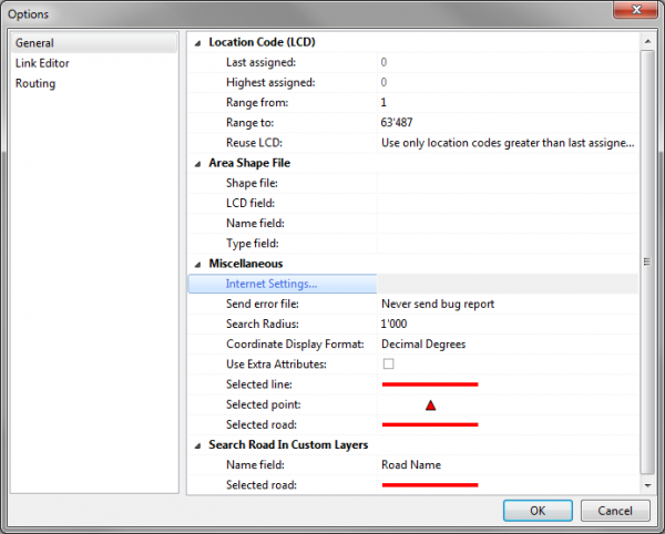
Area Shape File:
- Shape file
- Click on the field to the right of 'Shape File' and the on the folder icon to locate the directory where the shape file is stored.
- LCD field
- The field in which the LCD is located. Mandatory
- Name field
- The field in which the name is located. Optional
- Type field
- The field in which the type is located. Mandatory
Miscellaneous:
- Coordinate Display Format
- Here you can choose if the coordinates displayed in the bottom right hand corner of the screen should be displayed in decimal degrees or in minutes and seconds.
Link Editor

Link Editor → Enable
When using Link Editor this option should be enabled in order to activate the corresponding buttons and functions.
Network Database
→ Connection Settings
If you imported the network from a shapefile (see Import Network Database From Shapefile), all settings should already be in place. If not, click Connection Settings to open the corresponding window and enter the connection details according to the following instructions:
- Database Type
- Select Firebird (lokal) only!
- Database
- Click on the folder button
 to select the database (file format ist FDB).
- User name
- Has to be sysdba.
- Password
- Has to be masterkey.
→ Layer Properties
Opens the window Edit Layer Configuration File where you can configure the map display of the network layer.
Network Cache Files → Directory
Click on the folder button ![]() to define where the cache file should be stored.
to define where the cache file should be stored.
Display
→ Network Link: Define the color and pattern of network links on the map.
→ TMC Link: Define color and pattern of TMC links on the map
Add Point, Copy Point, Delete Point
When adding/coppying/deleting a point the program can complete existing Tmc links with new aditional links.
You can set the program to do so automatically: Complete Links
Since the program needs one or two seconds to complete the links this might however be an inconvenience.
In this case you can tell the program not to do so: Do not complete links
If you choose this option, you must however update the links (Link Editor → Update TMC links) once yo are done editing.
If you are only doing minor changes you can also set the program to Ask each time. This can however become irritating verry quickly.
Routing

Define a cost factor for the various road types. It depends on the structure of your network what makes most sense and gives the best results. As soon as you use the routing function you will see if the results make sense.