Difference between revisions of "Straße erstellen"
| Line 1: | Line 1: | ||
| − | [[:Category:Menü Bearbeiten|Menü Bearbeiten]] → | + | [[:Category:Menü Bearbeiten|Menü Bearbeiten]] → Straße erstellen | [[:category:Werkzeugleiste Bearbeiten|Werkzeugleiste Bearbeiten]] → Straße erstellen |
| + | |||
[[File:strasse-erstellen.png|link=|alt=]] | [[File:strasse-erstellen.png|link=|alt=]] | ||
| + | Mit dieser Funktion lässt sich eine neue Strasse in der [[Objektliste]] erstellen. Das Objekt trägt den Strassennamen 'Neue Straße' und lässt sich durch Klick auf das Objekt bearbeiten. | ||
| − | |||
| − | |||
| − | |||
| − | |||
| − | |||
| − | + | ==Informationen Achse== | |
| − | |||
| − | == | ||
The dropdwon list '''General''' contains 5 items that need to be filled in: | The dropdwon list '''General''' contains 5 items that need to be filled in: | ||
| Line 33: | Line 28: | ||
'''Second name''': The name of the location or intersection where this road ends. | '''Second name''': The name of the location or intersection where this road ends. | ||
| − | [[File: | + | [[File:neuestrasse.png|link=|alt=|400px]] [[File:altestrasse.png|link=|alt=|400px]] |
<br> | <br> | ||
| − | == | + | ==Nächste Schritte== |
| + | |||
To display the road on the map it requires '''points''' that now need to be added. This can be done by: | To display the road on the map it requires '''points''' that now need to be added. This can be done by: | ||
| Line 53: | Line 49: | ||
So if a road contains 60 points, it should be segmented into segments that individually contain less than 50 points. | So if a road contains 60 points, it should be segmented into segments that individually contain less than 50 points. | ||
| − | |||
| − | |||
| − | |||
| − | |||
| − | |||
[[Category:Werkzeugleiste Bearbeiten]] | [[Category:Werkzeugleiste Bearbeiten]] | ||
Revision as of 09:03, 18 September 2015
Menü Bearbeiten → Straße erstellen | Werkzeugleiste Bearbeiten → Straße erstellen
![]()
Mit dieser Funktion lässt sich eine neue Strasse in der Objektliste erstellen. Das Objekt trägt den Strassennamen 'Neue Straße' und lässt sich durch Klick auf das Objekt bearbeiten.
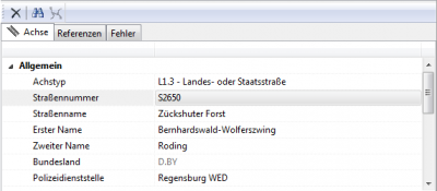
Informationen Achse
The dropdwon list General contains 5 items that need to be filled in:
Linear Subtype (chosen from a dropdown list):
This categoization helps order the individual pieces of road into hierarchical groups. This makes it easier to filter the roads later.
Choose the group this piece of road belongs to by double clicking on the space to the right of 'Linear Subtype' and then on the corresponding group.
Each group conatins one or more sub-categorizations (like 1st to 3rd class road). Clicking on one of these subgroups closes all the dropdown menus.
The remaining information needs to be entered manually:
Road name: The name of this road.
Road number: The number of this road.
First name: The name of the location or intersection where this road starts.
Second name: The name of the location or intersection where this road ends.

Nächste Schritte
To display the road on the map it requires points that now need to be added. This can be done by:
→ If the road has a unique name: by searching the road in Custom Layers ![]()
If you know that your road will have a large amount of points, you can also add a segment ![]() .
.
Segmenting the road will give a better overview when dealing with a large number of points.
Any single road or segment should not contain more than about 50 points.
So if a road contains 60 points, it should be segmented into segments that individually contain less than 50 points.