Difference between revisions of "Anzeigeeinstellungen bearbeiten"
| Line 7: | Line 7: | ||
<br> | <br> | ||
<br> | <br> | ||
| − | [[File: | + | [[File:Anzeigeeinstellungen_Auswahl.png|link=|alt=]] |
| Line 14: | Line 14: | ||
:'''Example''' which would result in no 'Area' elements, all 'Linear' elements, and 'Ponit' elements P3 to P5 being shown. | :'''Example''' which would result in no 'Area' elements, all 'Linear' elements, and 'Ponit' elements P3 to P5 being shown. | ||
| − | :[[file: | + | :[[file:Anzeigeeinstellungen_Fenster.png]] |
Revision as of 11:07, 10 August 2015
Toolbar Suchen → ![]()
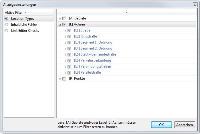
Über die Funktion Anzeigeeinstellungen bearbeiten... lassen sich die Daten auswählen, die in der Karte und im Datenbaum angezeigt werden sollen.
File:Anzeigeeinstellungen Auswahl.png
- Location Types
- By ticking the corresponding boxes, various 'Area', 'Linear' and 'Point' elements are included on the map and in the data tree.
- Example which would result in no 'Area' elements, all 'Linear' elements, and 'Ponit' elements P3 to P5 being shown.

- Semantic Errors
- The window displays all the errors found during the semantic checks. Ticking a box and clicking OK results in the corresponding errors being shown in the tree and on the map.
- Link Editor Checks (Only available in TMC Studio 'Editor')
- The window displays potential errors, generated when editing links. Ticking a box and clicking OK results in the corresponding errors being shown in the tree and on the map.
To deactivate any active filters, press ![]() .
.