Manage GIS Servers
Topics → ![]()
Use this window to manage eternal WMS-, SDE- and PostGIS-servers. These servers contain the geodata you can display in TMC-Editor.
If configured and available connections to servers already exist, they are listed in the GIS Server window on the left. To add new servers, use the buttons.
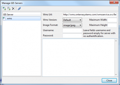
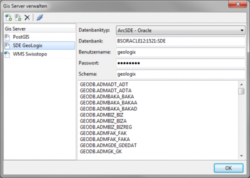
Clicking on an entry on this page will display the corresponding settings on the upper right hand side of the window. Beneath that you can read the output generated by testing the connection to current GIS Server (see below).
Terms and Definitions
For further details regarding certain terms used on this page please follow these links to the corresponding Wikipedia pages:
Buttons and their Functions
![]() Add Wms Server (left-hand image)
Add Wms Server (left-hand image)
Clicking this button will open a window where you can enter the caption/name you want to give this server. Clicking OK will add a server by the given name to the list on the left. You will then be required to enter the following configuration parameters on the right:
- Wms Url
- URL (internet address) of the WMS-Service.
- Wms Version
- Wms specifications supported by the map-server.
- Image Format
- The provided map sections will be displayed in TMC in this picture format. Usually several formats are supported but it depending on what type of map needs to be displayed some might be more suitable than others. JPEG is suitable for orthophotos and raster maps. PNG is optimal for GIS-data and GIF is best used for CAD- and survey data.
- Maximum Width und Maximum Height
- Here you can enter the maximum expansion (in pixels) of the map sections from the server. This only needs to be entered, if the map-server has limited the retrieveable data to a certain expansion (for instance to better control server workload when dealing with GetMap-requests) or if you are unsure if any limitations exist. Should latter be the case, a resolution of 2000x2000 pixels is a good choice. You might be able to find information regarding limitations in the <abstract> sections of the WMS-Capabilities. These can be found by clicking test connection to current GIS server (see below).
![]() Add GeoDb Server (right-hand image)
Add GeoDb Server (right-hand image)
Clicking this button will open a window where you can enter the caption/name you want to give this server. Clicking OK will add a server by the given name to the list on the left. You will then be required to enter the following information:
- Database type
- Choose the type of database you wish to connect to:
- PostGIS - PostgreSQL
- ArcSDE - Oracle
- ArcSDE - MS SQL
- Choose the type of database you wish to connect to:
- Database
- Here you are required to enter the server path to the corresponding database. Use the format [SERVER]:[DATABASE] or [SERVER]:[PORT-NO.]:[DATABASE] when using Oracle. For instance:
- TESTSERVER:test_DB
- BSORACLE12:1521:SDE
- Here you are required to enter the server path to the corresponding database. Use the format [SERVER]:[DATABASE] or [SERVER]:[PORT-NO.]:[DATABASE] when using Oracle. For instance:
- Username und Password
- Name (and the corresponding password) of the user who has the required rights to access the database.
- Schema
- Enter what kind of database schema you are using (is not always required).
Use this button to remove the currently selected server from the list. Note: You will not be prompted to confirm the removal!
![]() Test Connection to current GIS Server
Test Connection to current GIS Server
Clicking this button will test the connection to the server currently selected in the list. The results of this test are displayed in the window on the lower right-hand side.
When dealing with a WMS-server, this test serves as a GetCapabilities-request. If it is successful, all available metainformation on the server will be displayed.
If you are dealing with PostGIS- and ArcSDE-servers the test will generate a list with all the available attributes or (data)layers.
If the test is not successful, you are presented with an error message. For instance:
- ORA-01017: invalid username/password; logon denied: A wrong username or password was used when trying to connect to an Oracle-DB.
- Layer add error (Coordinate system not supported)!: Either the URL was incorrect or that coordinate system is not supported by the WMS-server.
- Cannot connect to database; Passwort-Authentification for User "postgress" failed: Invalid password or username for a PostGIS-server.

