Difference between revisions of "Edit topic file"
| Line 3: | Line 3: | ||
==General== | ==General== | ||
| − | The window '''general''' | + | The window '''general''' contains the name, the location of the topic file and the file for configuration, the coordinate system used and the filetype. |
| + | |||
| + | '''Scale''' determines the range in which the data is visible | ||
It is adviseable to use the same settings for screen and printer (this can be done by ticking the box '''apply for printer'''). This way a printout will look the same as displayed onscreen. | It is adviseable to use the same settings for screen and printer (this can be done by ticking the box '''apply for printer'''). This way a printout will look the same as displayed onscreen. | ||
[[File:Edit topics general.png]] | [[File:Edit topics general.png]] | ||
| + | |||
| + | |||
| + | Unter dem Reiter '''Zusatzthema''' sind Name, Speicherort des Zusatzthemas und der Konfigurationsdatei, Koordinatensystem und Dateityp aufgeführt. Hier lässt sich auch die massstabsabhängige Sichtbarkeit sowie die Deckkraft (0 = nicht sichtbar (voll transparent), 100 = deckend (keine Transparenz)) für Bildschirm und Drucker einstellen. Es wird empfohlen, für den Drucker dieselben Einstellungen wie für den Bildschirm zu übernehmen (Häkchen [[file:checkbox_checked.png|alt=|link=]] bei '''Für Drucker übernehmen''' setzen), so dass die Karte jeweils so gedruckt wird, wie sie sich am Bildschirm präsentiert | ||
| + | |||
==Files== | ==Files== | ||
Revision as of 11:46, 3 December 2013
Topics → ![]()
General
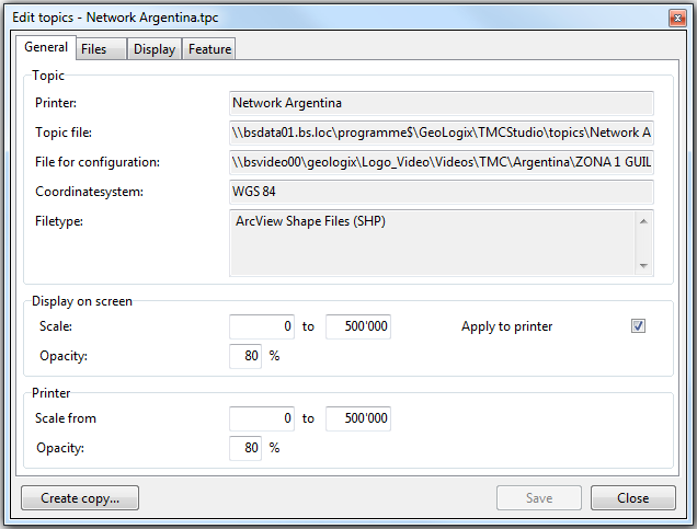
The window general contains the name, the location of the topic file and the file for configuration, the coordinate system used and the filetype.
Scale determines the range in which the data is visible
It is adviseable to use the same settings for screen and printer (this can be done by ticking the box apply for printer). This way a printout will look the same as displayed onscreen.
Unter dem Reiter Zusatzthema sind Name, Speicherort des Zusatzthemas und der Konfigurationsdatei, Koordinatensystem und Dateityp aufgeführt. Hier lässt sich auch die massstabsabhängige Sichtbarkeit sowie die Deckkraft (0 = nicht sichtbar (voll transparent), 100 = deckend (keine Transparenz)) für Bildschirm und Drucker einstellen. Es wird empfohlen, für den Drucker dieselben Einstellungen wie für den Bildschirm zu übernehmen (Häkchen ![]() bei Für Drucker übernehmen setzen), so dass die Karte jeweils so gedruckt wird, wie sie sich am Bildschirm präsentiert
bei Für Drucker übernehmen setzen), so dass die Karte jeweils so gedruckt wird, wie sie sich am Bildschirm präsentiert
